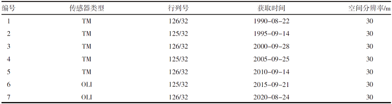
北方农业学报 ›› 2022, Vol. 50 ›› Issue (5): 112-118.doi: 10.12190/j.issn.2096-1197.2022.05.16

• 农业经济 · 农业信息技术 • 上一篇    下一篇

基于遥感信息的植被变化对岱海湖面积的影响

刘凯1,2, 孙丽2,3, 张志成1,4, 张鹏1, 刘金善1, 张存霞1   

  1. 1.乌兰察布市农林科学研究所,内蒙古 乌兰察布 012000
    2.农业农村部耕地利用遥感重点实验室,北京 100121
    3.农业农村部规划设计研究院,北京 100121
    4.内蒙古农业大学,内蒙古 呼和浩特 010018
  • 收稿日期:2022-08-29 出版日期:2022-10-20 发布日期:2023-01-10
  • 通讯作者: 孙丽
  • 作者简介:孙丽(1978—),女,高级工程师,博士,主要从事农业遥感应用与研究工作。
    刘凯(1989—),男,助理研究员,硕士,主要从事农业和生态环境遥感应用的研究工作。
  • 基金资助:
    2021年农业农村资源监测统计项目;内蒙古农牧业青年创新基金项目(2021QNJJN10)

Influence of vegetation change on the area of Daihai Lake based on remote sensing information

LIU Kai1,2, SUN Li2,3, ZHANG Zhicheng1,4, ZHANG Peng1, LIU Jingshan1, ZHANG Cunxia1   

  1. 1. Ulanqab Institute of Agriculture and Forestry Sciences,Ulanqab 012000,China
    2. Key Laboratory of Cultivated Land Use,Ministry of Agriculture and Rural Affairs,Beijing 100121,China
    3. Academy of Agriculture Planning and Engineering,Ministry of Agriculture and Rural Affairs,Beijing 100121,China
    4. Inner Mongolia Agricultural University,Hohhot 010018,China
  • Received:2022-08-29 Online:2022-10-20 Published:2023-01-10
  • Contact: SUN Li

摘要:

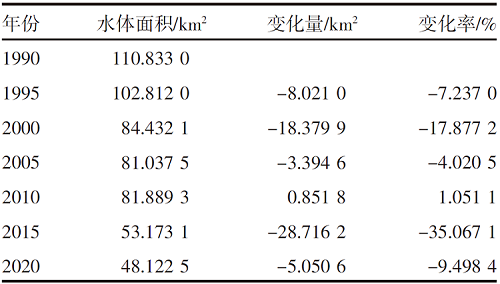
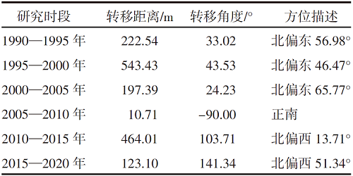
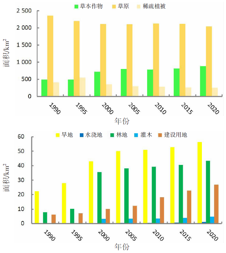
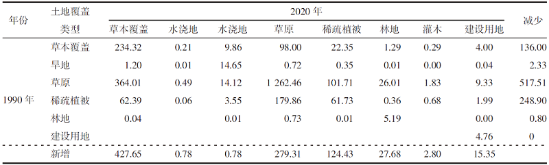
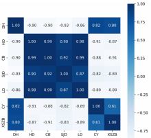
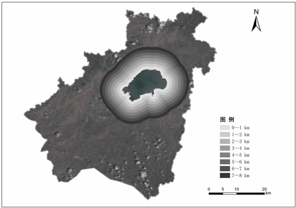
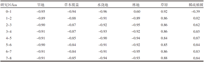
【目的】通过探索植被覆盖变化对岱海湖面积的影响,明确人类生产活动方式及范围与湿地变化的相互关系,为科学制定湖泊保护规划提供理论依据。【方法】研究区域为岱海湖主要支流形成的流域,在获取1990—2020年7期该区域遥感资料的基础上,采用重心迁移分析、土地类型转移矩阵、相关性分析等方法,分析流域内植被变化对岱海湖面积的影响。【结果】1990—2020年岱海湖面积呈下降趋势,1990年为110.833 0 km2,2020年为48.122 5 km2,减小62.710 5 km2,2005年以前湖面重心快速向东北方向转移,2005年以后逐步向北偏西方向迁移;岱海湖面积变化与旱地、草本覆盖、水浇地、林地呈显著负相关,相关系数分别为-0.90、-0.90、-0.93、-0.86;与草原和稀疏植被呈显著正相关,相关系数分别为0.82和0.80;岱海湖周边1 km内旱地、草本覆盖、水浇地、草原的面积与岱海湖面积变化相关性较高,相关系数分别为-0.95、-0.94、-0.96、0.92。【结论】岱海湖周边1 km内的农田开垦对原始草原植被的破坏是岱海湖面积缩减的主要生产活动因素。

关键词: 岱海湖面积, 植被覆盖, 遥感信息, 年际变化, 转移矩阵, 相关性分析

Abstract:

【Objective】By exploring the impact of changes in vegetation coverage on the area of Daihai Lake,clarify the relationship between the mode and scope of human production activities and wetland changes,provide a theoretical basis for the scientific formulation of lake protection planning.【Methods】The research area was the basin formed by the main tributaries of Daihai Lake. Based on seven sets of remote sensing data of the area from 1990 to 2020,the impact of vegetation change on the surface area of the Daihai Lake was analyzed using gravity center migration analysis,land type transfer matrix and correlation analysis.【Results】From 1990 to 2020,the surface area of Daihai Lake had a declining trend,which was 110.833 0 km2 in 1990 and 48.122 5 km2 in 2020,decreased by 62.710 5 km2. Prior to 2005,the gravity centre of the lake surface shifted rapidly to the northeast,and gradually moved to north by west after 2005. With correlation coefficients of -0.90,-0.90,-0.93 and -0.86,respectively,the area change of Daihai Lake was significantly negatively correlated with dry land,herbaceous cover,irrigated cropland and forest,and significantly positively correlated with grassland and sparse vegetation,with correlation coefficients of 0.82 and 0.80 respectively. The area of dry land,herbaceous cover,irrigated cropland and grassland within 1 km around Daihai Lake had high correlations with the area change of Daihai Lake,with correlation coefficients of -0.95,-0.94,-0.96 and 0.92 respectively.【Conclusion】The destruction of the native grassland vegetation by agricultural reclamation within 1 km around Daihai Lake was the primary production activity that contributed to the decrease in Daihai Lake′s surface area.

Key words: Daihai Lake area, Vegetation coverage, Remote sensing information, Interannual variation, Transfer matrix, Correlation analysis

中图分类号: 

  • P343.3