畜牧与饲料科学 ›› 2022, Vol. 43 ›› Issue (4): 93-103.doi: 10.12160/j.issn.1672-5190.2022.04.014

• 智慧畜牧业 • 上一篇    下一篇

基于无人机平台的牛体点云重构及体尺测量系统研究

石炜1,陈禹州1,张万锴2,张晓莹1,张国英3   

  1. 1.内蒙古科技大学机械工程学院,内蒙古 包头 014010
    2.内蒙古智牧溯源技术开发有限公司,内蒙古 包头 014010
    3.内蒙古中农高科科技有限公司,内蒙古 东胜 017010
  • 收稿日期:2022-04-07 出版日期:2022-07-30 发布日期:2022-07-21
  • 通讯作者: 陈禹州(1995—),男,硕士研究生,主要研究方向为三维重建、图像处理、点云处理。
  • 作者简介:石炜(1971—),男,副教授,博士,硕士生导师,主要研究方向为精密检测技术。
  • 基金资助:
    内蒙古自治区科技重大专项“基于物联网的内蒙古现代草原畜牧业生产监控及产品安全溯源平台建设”。

Cattle Point Cloud Reconstruction and Body Size Measurement System Development Based on Unmanned Air Vehicle (UAV) Platform

SHI Wei1,CHEN Yu-zhou1,ZHANG Wan-kai2,ZHANG Xiao-ying1,ZHANG Guo-ying3   

  1. 1. School of Mechanical Engineering,Inner Mongolia University of Science and Technology,Baotou 014010,China
    2. Inner Mongolia Zhimu Traceability Technology Development Co.,Ltd.,Baotou 014010,China
    3. Inner Mongolia Zhongnong Gaoke Science and Technology Co.,Ltd.,Dongsheng 017010,China
  • Received:2022-04-07 Online:2022-07-30 Published:2022-07-21

摘要:

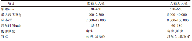
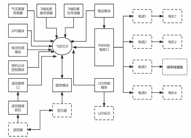
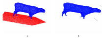
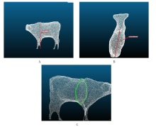
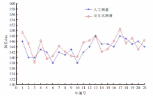
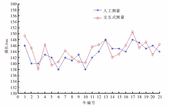
[目的]在现有动物体尺检测技术基础上,根据散养牛活动范围大、对环境不敏感、行动迟缓等特点,提出一种基于无人机离线三维重建获取牛体点云数据对其实现体尺非接触式测量的方法,实现可使用覆盖面广、精准、高效的牛体尺测量方案。[方法]首先,利用四轴无人机进行图片采集,借助中值滤波降噪、图像三通道直方图均衡化等图像处理方法,对图像进行预处理,提高重建点云密度及测量精度;然后,根据图片自带POS(position and orientation system)信息进行空中三角计算,获取平差确定点云的初始坐标数据之后进行三维重建;最后,通过PCL(point cloud library)点云处理中的随机采样一致性算法RANSAC,提取每头牛的点云,之后进行交互式测量。[结果]共采集4个牛群以及1头单体牛图像,重建可用点云共计21头牛体数据,测得的体高、体长、胸围与人工测量相比平均相对误差分别为3.87%、4.16%、5.06%。[结论]该方法可应用于内蒙古地区散养中低密度牛群的体尺测量,且误差在可接受范围内。

关键词: 体尺, 非接触式测量, 无人机, 图像处理, 三维重建, 交互式测量

Abstract:

[Objective] According to the characteristics of vast activity area, insensitivity to the environment and delayed movement of free range cattle population, by referring the existing animal body size measurement technology, a non-contact body size measuring system on the basis of unmanned air vehicle (UAV) off-line 3D reconstruction method capable of collecting cattle point cloud data was develped to establish a wide coverage, precise, and high-efficient cattle body size measurement solution. [Method] Firstly, a quad-axis UAV was used to capture images, and some image processing techniques such as noise reduction with median filter and image three-channel histogram equalization were utilized to preprocess the image and to improve the reconstructed point cloud density and measurement accuracy. Secondly, the aerial triangulation measurement was conducted using the position and orientation system (POS) information from the image, and the 3D model was reconstructed after the initial coordinate data of point cloud was confirmed by adjustment computation. Finally, the point cloud of individual cattle was extracted by using random sample consensus (RANSAC) algorithm in point cloud library (PCL) and then interactive measurement was made. [Result] Images from 4 cattle herds and 1 individual cattle were collected, and available point cloud of body size data from a total of 21 cattle were reconstructed. In comparision to the convetional manual measurement method, the average relative errors in body height, body length and chest circumference measured by the developed UAV based system were 3.87%, 4.16% and 5.06%, respectively. [Conclusion] The UAV based system developed in this study can be used to measure body size of medium- and low-density free range cattle herds in Inner Mongolia, and the error is within the acceptable range.

Key words: body size, non-contact measurement, unmanned aerial vehicle, image processing, 3D reconstruction, interactive measurement

中图分类号: